June 26, 2020
|
Link Cheng
What is a Geofence?
What is a Geofence, and How Can I Use It?
A geofence is a virtual border or edge around a location on a map. You might think of this as the virtual fence, or perimeter, around your yard or job site. You can set one or several. Geofences can be overlapping, or even concentric. A geofence is a tool typically used in mapping, routing, shipping or dispatch applications in fleet management.
The best fleet management software for GPS telematics should enable you to quickly and simply create, manage, and update geofences on a Google map. As a fleet manager, you should be able to easily create geofences on a map, using your mouse on a desktop to just click and draw. Ideally, your geofences can be circles around a point, or freeform shapes.
A geofence is used to identify both permanent and temporary locations. For example, you may have a permanent location where your business fleet is located, such as the yard. This might be set up for all vehicles and rolling assets. You may also have temporary use geofences, such as at a job site which will be active for the next 6 weeks, or a home site, where a vehicle may be temporarily visiting.
How to Set Up a Geofence
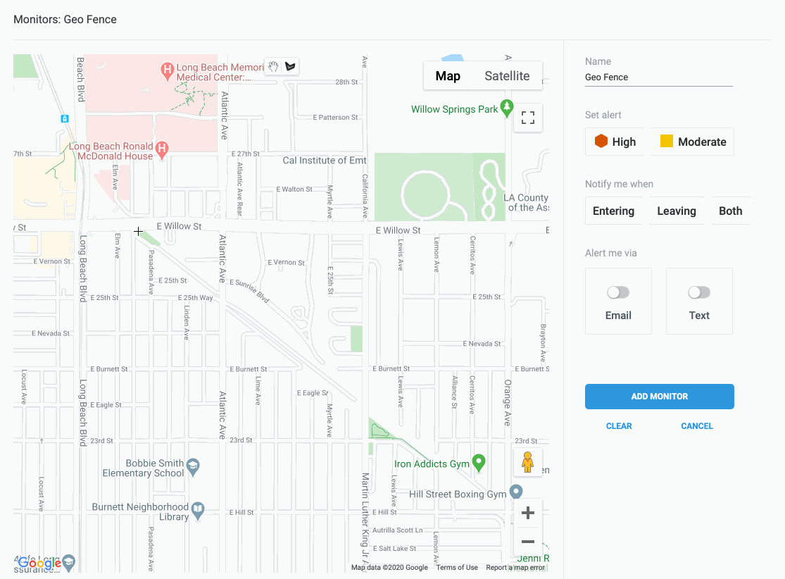
In your fleet management application, find the monitors, notifications, and alerts setup area. In Momentum IoT, there is a tab for “Monitors.” Click it to set a unique monitor. A telematic fleet management application can have several monitors, such as a disconnect, battery voltage, excessive idling, or speeding monitor. Select the Geo Fence monitor. Now just move your cursor over to the map with your mouse, and begin drawing. If the map is not set up in a location that works for you, just drag it, like you would any Google Map.
Start to create a geofence by clicking on the map. This will be the beginning of a perimeter you create around the location. The perimeter can be a city block, or any shape you like. Click again on the map to set the first part of the geofence, and keep clicking until you have a shape you like. Once you come back around to the start, you can just click on the original dot, and the bounded area will now be shaded. You’ve just created a geofence!
You can name your geofence, so you remember the location. You can determine whether you will get an alert when a vehicle enters or exits this geofence, or both. You can set the severity of the notification, and you can choose whether you want to receive the alert via e-mail or text.
Click “Add Monitor” and you’re done.
How to Use a Geofence
One obvious use of a geofence is to track whether an employee has arrived at a site. You can also see how long your crew stayed at a job site, and whether they left early.
You can also set concentric circles around a site, so that you get alerts as shipments or deliveries get closer to your destination.
Managers also are increasingly using geofences to track off-hours use of vehicles. This is increasingly important if fleet vehicles are driven home after a work day.
Other Uses
Geofences are also used to track and label multiple office locations, and to pair vehicles to locations. For example, a vehicle can be assigned to your Long Beach location, and used as a primary resource for that location, but be available for dispatch in other locations. Other vehicles, which are assigned to your Corona office location, may be nearer, but are not suitable for a Long Beach assignment because of their location association.
What is Asset Sharing?
Some GPS telematics applications also enable “asset sharing.” In this use case, vehicle and equipment location information can be shared with a temporary user, such as a customer. This addresses a particular need in an equipment rental business, when a piece of equipment is set to arrive at a location at a specific time, and for a specific duration. You can set up to send your customer a text when the asset arrives, and also if it leaves the customer’s site.
Limitations
Geofences have limitations as tools to help you manage a field services fleet, with drivers and rolling assets on the move to and from multiple job sites. Here are some factors to consider:
Accuracy of the GPS location
Devices used in fleet telematics have a wide range of accuracy. The range can, in turn, be affected by hardware, network, and server factors. For example, advanced GPS chipsets in a device don’t help if the system is antiquated, or servers are slow. You may have a GPS location which is accurate, but out of date. All components of the system (hardware, platform, application) should ideally be blazing fast, and highly accurate. On the high end, fleet management GPS telematics tools are able to offer near real-time dashboards, with an accuracy of 1.5–2 meters, and update every 10 seconds during a trip. This allows you to see dots moving on a map. For example, just as you can see vehicles on a street map using your Uber app, you should be able to see your fleet vehicles moving on the map.
Existence of and accuracy of an Accelerometer
Some GPS Telematics solutions in the market offer devices which do not include an on-board accelerometer. This is a significant drawback. With a high-resolution accelerometer, smart developers can manage the device so that GPS information can be conveyed at the right instant, for example, as soon as a vehicle is in motion. An accelerometer can serve as an in-device early trigger for power management, beginning and ending of trips, and other useful features.
Exit/entry monitors
A good user interface would enable you to both create geofences easily, and also to add, edit, and delete monitors with ease. Monitors should be able to send you alerts in three ways: 1) email, 2) text, or 3) in-application.
Bluetooth BLE extensions
Bluetooth, and bluetooth low-energy (BLE) transceivers are included as part of high-end GPS telematics systems. When used in tandem with geofences, these BLE transceivers enable a wide variety of valuable features which extend the benefits of your GPS telematics system. For example, a BLE transceiver connected to a key fob can enable a plumbing business to make sure that the right driver is driving the right vehicle, and BLE stickers on equipment can enable that same business to make sure the plumber doesn’t lose equipment after a job is complete.
READ MORE:
Industry Accolades in Fleet Tracking
Momentum IoT has won several industry awards and analyst accolades:
- Momentum IoT Wins 2019 IoT Innovator Silver Medal
- Momentum Takes Home Top Award for Fleet Management Tracking at 2019 CompassIntel Awards
- Momentum IoT Named “Mobile IoT Innovator” by GSMA
- Mind Commerce Asset Tracking 2020–2025 Report singles out Momentum IoT
Additional Press: